Liquid Earth
Liquid Earth
 the world, and which have produced a very useful record for over a century. If one could account for all the tectonic vertical motions of those coastlines (epeirogeny), it would be possible relate these records to eustatic variations. This has been attempted by many researchers over the decades, with some success. The problem with measuring eustasy is that we measure land elevation with respect to sea level, while at the same time, we measure sea level with respect to the land surface along the coasts. This is untenably circular reasoning. In order to properly measure eustasy directly, it is necessary to define an appropriate reference frame. The lack of simple frames of reference has caused some researchers to give up on the concept of eustasy altogether. Reference frames are difficult to come by, as you must essentially measure the average height of the ocean surface relative to the center of the Earth (which we can do now with satellite altimeters, but we didn’t have those in the Cretaceous). However, one proxy for this for the Mesozoic and Cenozoic time frame may be found on the Russian Platform, where flat-lying Mesozoic sediments are found at the surface, having never been buried, and thus remain unconsolidated (Jurassic beach!). On the basis of the stratigraphic sequences found on the Russian Platform and surrounding basins, it has been possible to construct a eustatic sea level curve for the Jurassic and Cretaceous, when the region was generally flooded by high seas levels.
 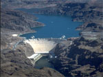 affects sea level. There are many human activities that have transferred water from the continents to the ocean, thus raising sea level. A few of these include ground water mining of fossil aquifers such as the Ogallala, draining of wetlands, and deforestation. On the other hand, a globally significant volume of water has been impounded on the continents by dam construction in the last 100 years, and the total rate of new dam construction appears to outweigh the rate of anthropogenic activities that add water to the oceans. When a new dam is constructed, while the reservoir fills for the first time, it holds back water that would have gone to the ocean. Once filled, the reservoir plays no further role in reducing the rate of sea level rise, but another dam is always being built somewhere (until recently). So the rate of water impoundment can be tallied and the extent to which people have reduced the rate of sea level rise can be figured. It turns out that the rate of reservoir filling closely balanced the rate of positive contributions to sea level rise, so the net anthropogenic impact would be zero. However, while there are tallies of the volume impounded by large dams, there are no estimates of the amount stored in small reservoirs down to the size of the ubiquitous farm ponds and rice paddies, which may cumulatively account for as much water as that stored in large reservoirs. Because a surface lake is merely a place where the ground surface dips below the water table, it is also necessary to take into account the effect of ground water impoundment in response to dam construction. This has never been done in any water resource compilations. As such, people may have been masking the true rate of sea level rise by as much as 2 mm/yr. If new dam construction is not maintained at the same pace as it has for the last 50 years, the observed rate of sea level rise will increase in the 21st century, even if all other (e.g. climatic) factors remain equal. Indeed, we have essentially stopped building dams (except Three Gorges), and it may be no coincidence that we have seen a recent increase in the rate of sea level rise from the 1.5-1.75 mm/yr of the 20th century, to over 3 mm/yr in the last decade.
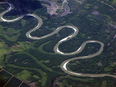 Meandering Rivers - The cause of river meanders has remained a puzzle for centuries, despite a great deal of analysis of river morphology, sediment transport, and fluid mechanics. The traditional approach has been to attribute meanders to river banks that erode preferentially due to a perturbation in the flow, with sinuosity growing in amplitude due to sediment erosion and deposition. In part, this focus on sediments and banks may be due to the lateral and longitudinal migration of meander bends leading to destabilization of bridge foundations and other built infrastructure, including over 600,000 major river crossings, most of them over meandering rivers.
What has not been satisfactorily demonstrated is why some rivers (or parts of rivers) should tend to meander in the first place rather than ply a straight course to base level. Furthermore, meandering tendencies can be observed in many other systems that do not involve sediments or erodible banks. Preliminary investigation has identified several natural systems that exhibit meandering, all apparently subject to the same fundamental instability, but which is manifest in different ways. In addition to rivers, these systems include the gulf stream, window glass, glacial meltwater, the jet stream, channels in submarine fans, and even water falling directly down from a faucet. Thus, the hypothesis that serves as the basis for this research is that there is a fundamental instability inherent in any flow that decelerates due to either an obstruction downstream or a reduction in driving forces, leading to an adverse pressure gradient. In any case, it is already clear that, contrary to hypotheses commonly advocated in the literature, the erodible banks of, or sediment availability within, a river system are neither necessary nor sufficient for the development of meandering.